


ST. CLAIR WD MIDDLE, Schuylkill County, Pennsylvania
About
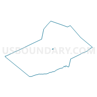
Outline

Summary
| Unique Area Identifier | 663764 |
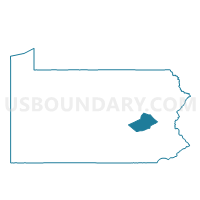
| Name | ST. CLAIR WD MIDDLE |
| County | Schuylkill County |
| State | Pennsylvania |
| Area (square miles) | 0.16 |
| Land Area (square miles) | 0.16 |
| Water Area (square miles) | 0.00 |
| % of Land Area | 100.00 |
| % of Water Area | 0.00 |
| Latitude of the Internal Point | 40.72122750 |
| Longtitude of the Internal Point | -76.18614500 |
Maps

Graphs
Select a template below for downloading or customizing gragh for ST. CLAIR WD MIDDLE, Schuylkill County, Pennsylvania


Neighbors
Neighoring Voting District (by Name) Neighboring Voting District on the Map
- EAST NORWEGIAN TWP Voting District, Schuylkill County, PA
- ST. CLAIR WD NORTH, Schuylkill County, PA
- ST. CLAIR WD SOUTH, Schuylkill County, PA
Top 10 Neighboring County Subdivision (by Population) Neighboring County Subdivision on the Map
- St. Clair borough, Schuylkill County, PA (3,004)
- East Norwegian township, Schuylkill County, PA (863)